Skip to main content

When pipeline spills happen, assessing the damage is crucial for cleanup and long-term recovery. Environmental Impact Assessments (EIAs) help identify contamination, protect public health, and meet legal and regulatory requirements. These evaluations cover soil, water, air, and ecosystems, but they come with challenges like detecting complex contamination patterns, accessing remote sites, and navigating overlapping regulations.
Key takeaways:
The article explores tools, techniques, and strategies for improving assessment accuracy while minimizing disruption to the environment.
Assessing the environmental impact after a pipeline spill is no small task. It involves tackling technical, regulatory, and logistical hurdles, all while racing against time to minimize further damage. These challenges can slow down cleanup efforts and compromise the accuracy of collected data. Below, we break down the key obstacles related to measurement, site access, and regulatory coordination.
Post-spill assessments demand quick, precise data collection. However, rushing the process can lead to incomplete findings, delaying remediation and leaving affected communities vulnerable. This highlights the importance of streamlined and reliable assessment methods.
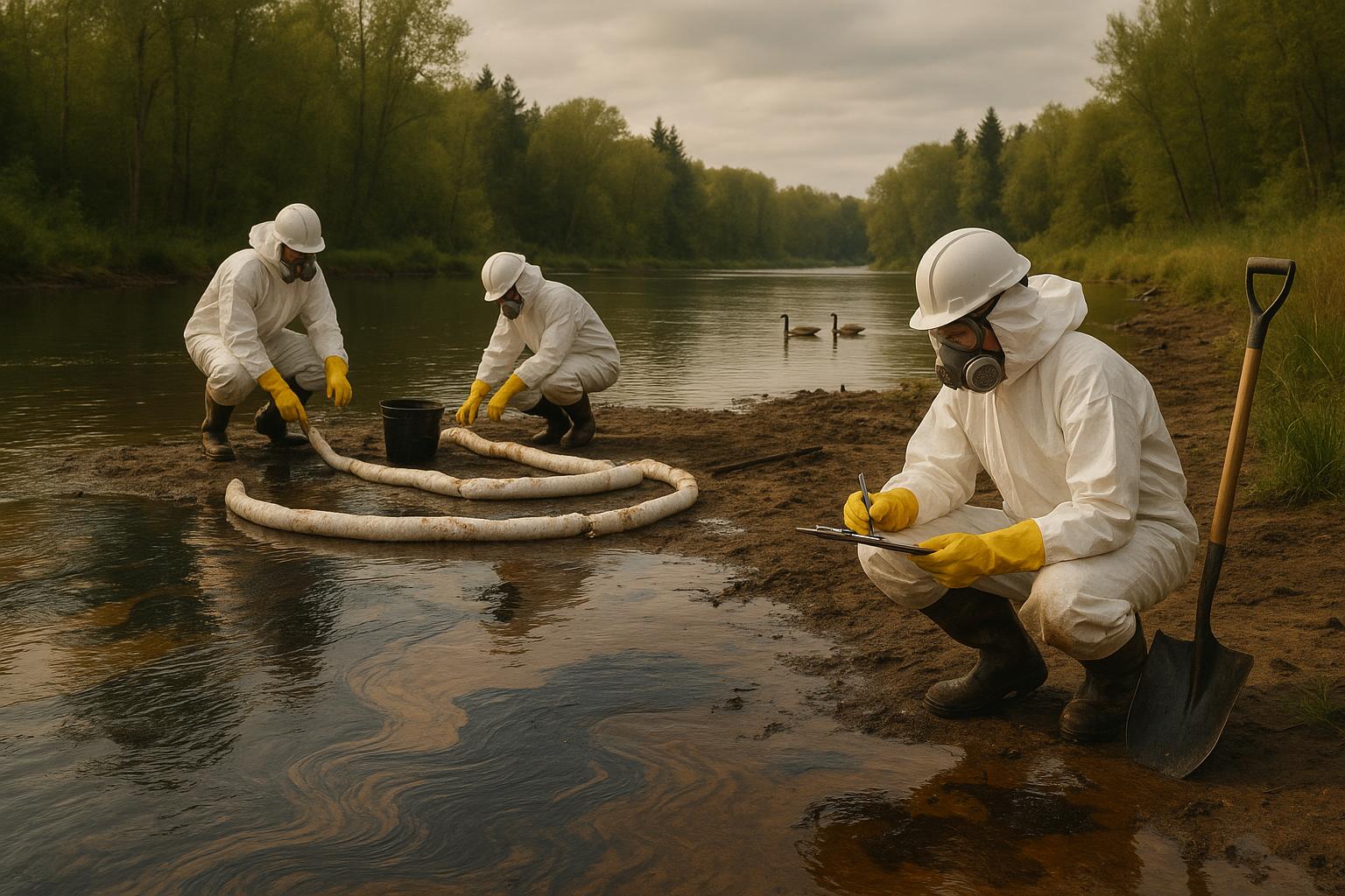
Measuring hydrocarbon contamination in soil and groundwater is a complex process requiring advanced tools and expertise. Different hydrocarbons behave differently in various environments, adding layers of difficulty. For instance, lighter hydrocarbons can quickly spread through sandy soils, while heavier ones may cling to clay particles, creating concentrated contamination zones.
Groundwater contamination poses its own set of challenges. Contaminants don’t spread evenly; instead, they follow geological features like fractures and flow paths, making them hard to track and increasing the risk of underestimating cleanup costs and timelines.
Air quality monitoring adds yet another layer of complexity, especially when volatile organic compounds are involved. Factors like weather, temperature changes, and wind patterns can cause contamination levels to fluctuate, complicating accurate readings. To make matters worse, contaminants often move between soil, groundwater, surface water, and air, creating interlinked issues that standard testing protocols may struggle to address.
Technical challenges aside, logistical barriers can significantly delay assessments. Many pipelines run through remote or difficult-to-reach areas, such as mountains, wetlands, or dense forests. These locations often require specialized vehicles and equipment, making it harder to transport the heavy tools needed for monitoring.
Weather conditions and equipment breakdowns further complicate matters. Harsh environments and corrosive substances can damage tools, halting operations for days or even months. Teams need reliable backup plans and on-site repair options to keep things moving. Additionally, traditional excavation methods can disrupt sensitive ecosystems, making advanced, non-invasive techniques - like those offered by companies such as Legacy HydroX - a better choice.
Coordinating tasks like soil sampling, air quality testing, water analysis, and site documentation adds another layer of complexity. All of this must be done while following strict safety guidelines and avoiding duplication of efforts.
Accurate assessments aren’t just critical for cleanup - they’re also essential for meeting regulatory and stakeholder expectations. Federal and state regulations often overlap, creating confusion about which standards to follow. For example, while the EPA sets federal guidelines, state agencies may enforce stricter rules, forcing assessment teams to navigate a maze of compliance requirements.
Coordination between multiple agencies - such as environmental departments, transportation authorities, local emergency teams, and sometimes tribal governments - can further slow the process. Each group has its own priorities and timelines, adding to the complexity.
Public and media scrutiny adds another layer of pressure during high-profile spills. Affected communities demand immediate updates on health risks and property impacts, while the media expects regular progress reports. Striking a balance between transparency and scientific accuracy becomes crucial.
On top of that, managing stakeholder expectations is no easy feat. Spills often impact multiple property owners, each with unique concerns and demands. Legal teams, insurance companies, and regulatory bodies may require different documentation, making meticulous record-keeping and careful planning essential for navigating these competing priorities.
Addressing the challenges of environmental assessments after a spill demands a mix of cutting-edge technology, established methods, and teamwork. The goal is to gather accurate data quickly while causing as little disruption to the environment as possible. This involves specialized tools and strategies designed to collect reliable information efficiently. Below, we explore advanced analysis techniques, non-destructive excavation methods, and the importance of coordinated team efforts in tackling these challenges.
Effective contamination detection hinges on sophisticated sampling and analysis methods. High-resolution soil sampling provides detailed contamination maps by using closely spaced sampling points. This approach uncovers contamination patterns that might otherwise go unnoticed, especially in areas with irregular geological features.
Real-time hydrocarbon detection tools are game-changers for on-site assessments. Portable analyzers allow teams to pinpoint contamination hotspots instantly, eliminating the delays associated with waiting for lab results. This flexibility helps teams adjust their strategies as conditions evolve.
Remote sensing technologies have transformed large-scale assessments. Thermal infrared imaging identifies temperature changes that may indicate subsurface contamination, while ground-penetrating radar reveals underground flow patterns and geological structures that influence contaminant spread. These techniques provide a comprehensive view of the contamination before teams even break ground.
Biological monitoring adds another layer of understanding. Soil microbiology assessments highlight how contamination impacts beneficial organisms, while vegetation stress analysis identifies vulnerable plant communities. Monitoring wildlife health also sheds light on bioaccumulation risks within local ecosystems.
For groundwater, multilevel monitoring wells have improved precision. These wells sample water at different depths simultaneously, offering insights into how contamination moves through various geological layers. This information is crucial for predicting long-term effects and planning effective cleanup efforts.
Once contamination is identified, non-destructive excavation methods help limit additional environmental damage. Traditional excavation can disrupt ecosystems, but hydrovac excavation provides a less invasive alternative. This method uses pressurized water to loosen soil and a vacuum system to remove it, exposing contaminated areas without harming surrounding vegetation or underground utilities.
Legacy HydroX, a leader in hydrovac services, supports environmental assessment projects across various industries. Their approach is particularly valuable in sensitive areas like wetlands or near critical infrastructure, where traditional methods pose greater risks.
Another helpful tool is hydro jetting, which cleans contaminated surfaces and equipment using high-pressure water streams, eliminating the need for harsh chemicals. This technique is often used to decontaminate pipelines, storage tanks, and other infrastructure, reducing the risk of spreading contaminants during the assessment process.
Hydrovac methods also allow teams to precisely define excavation boundaries, minimizing the area of disturbance. This targeted approach lowers restoration costs and accelerates site recovery once the assessment is complete. Additionally, utility locating services help prevent accidental damage to underground infrastructure, such as gas lines or water systems, during excavation activities. Accurate mapping ensures safety and avoids complications.
Combining advanced tools with coordinated expertise ensures the accuracy and effectiveness of post-spill assessments. Collaboration among specialists from various fields is essential. For example, environmental scientists design sampling protocols, hydrogeologists analyze groundwater flow, and ecological specialists evaluate impacts on wildlife and vegetation. Meanwhile, regulatory compliance experts ensure that all activities align with legal requirements.
Integrated data management systems streamline collaboration by allowing specialists to share information in real-time. Cloud-based platforms enable field teams to upload sampling results instantly, while lab personnel access site maps and protocols remotely. This reduces delays and ensures consistent, high-quality data.
To maintain reliability, quality assurance protocols are critical. Chain-of-custody procedures track samples, while duplicate and blind quality control tests verify lab accuracy. Regular calibration of field instruments ensures consistent measurements throughout the project.
Keeping stakeholders informed is another key element. Clear communication strategies ensure everyone stays updated without compromising scientific integrity. Regular briefings, technical reports, and public information sessions address concerns and explain findings in an accessible way.
Cross-training team members enhances field efficiency and reduces errors. For instance, soil sampling specialists who understand groundwater flow can adjust their methods for better data collection, while excavation crews trained in ecological sensitivities can minimize habitat disruption.
Finally, emergency response protocols safeguard both team safety and data quality during challenging conditions. Pre-positioned equipment and backup crews keep operations running smoothly, even during weather delays or equipment failures. Strong communication links ensure field teams stay connected with technical support and regulatory bodies throughout the process.
Post-spill Environmental Impact Assessments (EIAs) must comply with a range of federal and state laws designed to ensure thorough investigation, proper documentation, and accountability. These regulations are not just about ticking boxes - they play a key role in protecting public interests and guiding responsible environmental management. A core part of compliance involves maintaining detailed records.
The Environmental Protection Agency (EPA) lays out the primary requirements for post-spill assessments under several major laws. One of the most important is the Comprehensive Environmental Response, Compensation, and Liability Act (CERCLA), also known as Superfund. CERCLA requires responsible parties to conduct Remedial Investigation and Feasibility Studies (RI/FS) to determine the extent of contamination and explore cleanup options.
The Clean Water Act focuses on spills impacting surface waters and wetlands. Section 311 mandates that authorities be notified within 24 hours of a spill. This law also requires Natural Resource Damage Assessments (NRDA) to evaluate harm to natural resources and outline restoration strategies.
For operators of hazardous liquid pipelines, the Department of Transportation (DOT) has specific regulations under 49 CFR Part 195. These rules require integrity assessments and Pipeline Integrity Management Programs, which include environmental considerations. In the event of a spill, operators must follow DOT’s reporting guidelines and conduct assessments within set timelines. These steps influence both the immediate response and longer-term cleanup and monitoring efforts.
State-level regulations often add another layer of complexity. State Environmental Protection Agencies may require additional notifications, permits for assessment activities, or stricter cleanup standards. For example, some states mandate groundwater monitoring for spills above certain thresholds or require ecological risk assessments for spills near sensitive ecosystems.
If pipeline spills occur in areas with underground storage tanks, Underground Storage Tank (UST) regulations under 40 CFR Part 280 come into play. These rules establish cleanup standards based on current and future land use.
Additionally, when federal agencies are involved in spill response, the National Environmental Policy Act (NEPA) may require Environmental Assessments or Environmental Impact Statements for major cleanup projects, adding yet another layer of regulatory oversight.
Thorough documentation is the backbone of regulatory compliance and transparency. For significant spills, an Initial Notification Report must be submitted - usually within 24 hours. This report includes key details such as the estimated spill volume, affected areas, and immediate response actions.
Following this, comprehensive assessment reports are required. These reports detail sampling methodologies, analytical results, quality assurance protocols, and contamination maps. The EPA mandates the use of SW-846 Test Methods to ensure consistency and reliability in data.
To maintain sample integrity, chain-of-custody records are essential. These records document every step, from sample collection to laboratory analysis, and are critical during regulatory reviews or legal proceedings.
Data validation reports are another key component, confirming that analytical results meet regulatory standards. These include details like method detection limits, quality control results, and assessments of data usability. Agencies rely on this information to evaluate whether the findings support proposed cleanup actions.
For longer assessment periods, progress reports are typically required on a monthly or quarterly basis. These updates keep agencies informed about ongoing fieldwork, preliminary results, and future plans, demonstrating a commitment to compliance.
Final assessment reports pull everything together, presenting a complete picture of the investigation. These include conceptual site models, risk assessments, analyses of cleanup options, and recommended actions. These reports must be detailed enough to satisfy all regulatory requirements and enable agency review and approval.
To streamline reporting, electronic systems like the EPA’s Envirofacts database and state-specific platforms are often used. These systems standardize data submissions, improve transparency, and provide public access to assessment information.
Public involvement is another critical aspect. Regulations require public notices, community meetings, and comment periods for major findings. Documentation must reflect how public feedback was considered and incorporated into decision-making.
Lastly, financial assurance is a key requirement. Responsible parties must provide evidence - such as insurance policies, surety bonds, or financial statements - that they can cover the costs of assessment and cleanup.
Record retention rules ensure that documentation remains accessible for decades. Most regulations require records to be kept for at least 30 years, with some data requiring permanent retention. Effective record management systems are crucial for meeting these long-term requirements and ensuring accessibility for future regulatory or legal needs.
Long-term monitoring and recovery plans are essential for preventing recurring contamination and ensuring ecosystems are restored to their natural balance. These programs involve continuous tracking of recovery progress and adapting strategies to address changing conditions.
After initial assessments, long-term monitoring protocols help validate cleanup efforts and track environmental recovery over time. This involves systematically monitoring soil, water, and air conditions. Establishing a clear baseline is crucial to measure any changes accurately and assess recovery progress. Data collection is conducted methodically to identify residual contamination and document the recovery process. Beyond spill-specific contaminants, it's also important to monitor broader environmental factors that could influence recovery.
Water testing, for instance, includes both surface and groundwater analysis to detect any migration of contaminants. Chemical testing confirms the sources of contamination and ensures comprehensive understanding of the spill's impact. Soil monitoring examines both surface and subsurface layers, often utilizing non-invasive techniques like hydro-excavation. This method minimizes disruption to the recovering ecosystem while allowing access to deeper soil layers. Air quality monitoring is another critical component, particularly for detecting volatile organic compounds (VOCs) from petroleum products, which can become more active during warmer months.
By maintaining a robust and detailed monitoring system, recovery teams can make well-informed decisions to refine their strategies.
Ecological and biological assessments provide deeper insights into how ecosystems are recovering. Techniques such as ecological surveys, ecotoxicological testing, and biodiversity studies help measure the impact on plants, animals, and various ecosystem components. These assessments are complemented by socio-economic and human health studies, which evaluate potential long-term risks to local communities and monitor exposure levels.
A key objective in these recovery plans is enhancing the resilience of natural systems, ensuring they are better equipped to handle future disturbances. Strengthening ecosystem resilience not only aids in recovery but also reduces the likelihood of similar issues arising again.
Regular reviews ensure that recovery efforts remain effective and that communication with the public reflects the latest developments.
Routine audits are vital for keeping monitoring and recovery programs on track. These periodic reviews assess whether the protocols in place are gathering the necessary data and whether recovery strategies are achieving their goals. Updates provided to regulatory agencies ensure compliance with guidelines and maintain transparency.
Given the public attention surrounding large-scale spills, clear and timely communication about recovery progress is essential for building trust within affected communities. Socio-economic impact assessments also play a role in tracking how recovery efforts influence local livelihoods and industries, ensuring that the needs of the community are addressed alongside environmental restoration.
When it comes to managing spill assessments, success often depends on quick action, accurate data, and seamless teamwork. These elements are the backbone of timely cleanups and long-term recovery efforts. Let’s break down the essentials.
Speed and accuracy are critical right from the start. The initial response phase lays the groundwork for everything that follows. Teams need to act fast to establish baseline conditions before the situation changes further. This requires having equipment and trained personnel ready to mobilize within hours. A solid, rapid start ensures that every subsequent step is built on reliable data.
Cross-disciplinary expertise is another cornerstone of effective assessments. Specialists like environmental scientists, hydrogeologists, ecologists, and regulatory experts each bring unique insights to the table. Early collaboration among these experts helps identify key issues and leads to better solutions.
Non-destructive investigation methods are vital for gathering subsurface data without creating further harm. Techniques like hydro-excavation allow teams to safely access contaminated soil and underground utilities. This approach provides essential data for cleanup while minimizing disruption to the environment.
Thorough documentation is a must. Records need to meet immediate operational needs while also satisfying long-term regulatory requirements. Detailed documentation supports ongoing monitoring and can be crucial for legal and insurance purposes.
Community engagement plays a crucial role in building trust. Regular, transparent updates help address local concerns and foster a sense of cooperation, ensuring that the community feels informed and involved throughout the process.
Technology integration enhances both speed and precision. Tools like real-time monitoring systems, satellite imagery, and advanced analytical equipment provide a wealth of data that traditional methods can’t match. However, human expertise remains irreplaceable - skilled professionals are needed to interpret this data and make informed decisions quickly.
Assessing environmental damage after a pipeline spill isn’t straightforward. One of the biggest hurdles is accurately measuring how far contamination has spread in both soil and water, especially in delicate ecosystems. Factors like seasonal changes and natural recovery processes further complicate predicting the long-term effects on the environment.
Another tough aspect is distinguishing the spill's immediate effects from pollution that was already present in the area. This overlap can make long-term monitoring tricky and create obstacles in planning effective cleanup strategies. Tackling these challenges calls for advanced tools and techniques to deliver precise and dependable evaluations.
Modern tools like AI-powered sensors, satellite imaging, and real-time monitoring systems have transformed how contamination is detected after pipeline spills. These technologies make it possible to pinpoint spill boundaries and assess contamination levels with greater speed and accuracy, leading to faster responses and more targeted cleanup efforts.
By simplifying and accelerating the detection process, these innovations help limit environmental harm and lessen long-term consequences. Using these advanced systems allows for a more responsive and effective way to handle pipeline spill incidents.
Federal and state regulations are essential in guiding how Environmental Impact Assessments (EIAs) are conducted following pipeline spills. These laws set the groundwork for managing spill responses, monitoring environmental effects, and ensuring compliance to safeguard both ecosystems and public health.
For instance, the Oil Pollution Act (OPA), overseen by the EPA, requires companies to prepare spill response plans and evaluate the environmental consequences of spills. Similarly, the Pipeline and Hazardous Materials Safety Administration (PHMSA) enforces safety standards, which include leak detection and repair protocols that often incorporate environmental assessments. Together, these regulatory frameworks create a structured approach to addressing spills, helping to reduce long-term ecological harm.
Lorem ipsum dolor sit amet, consectetur adipiscing elit, sed do eiusmod tempor incididunt ut labore et dolore magna aliqua. Ut enim ad minim veniam, quis nostrud exercitation ullamco laboris nisi ut aliquip ex ea commodo consequat. Duis aute irure dolor in reprehenderit in voluptate velit esse cillum dolore eu fugiat nulla pariatur.
Block quote
Ordered list
Unordered list
Bold text
Emphasis
Superscript
Subscript